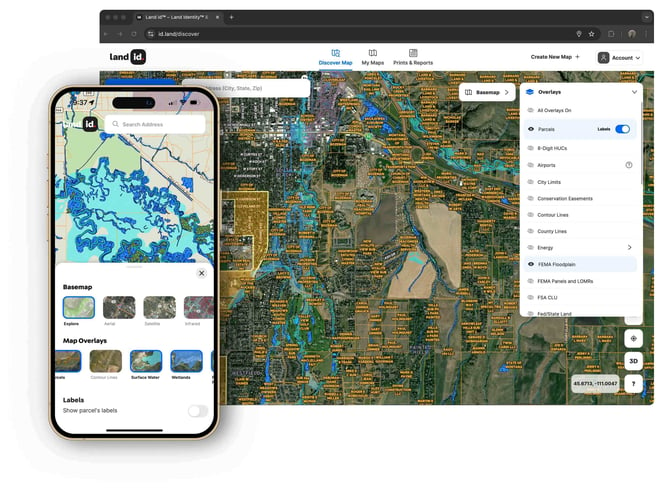
Overlay Summary
Learn about Land id® overlays, including definition, available overlays and their coverage, benefits and tips for using overlays.
How to use overlays for a single parcel
How to use overlays for a larger area of interest
Available with any of the following subscriptions:
- All plans
Definition
Land id overlays are comprised of various datasets that users can scroll through--or toggle on or off--to visualize information on maps.

The GIS team at Land id is dedicated to maintaining the highest standards of data integrity. We work closely with data providers and customers to ensure the highest-quality data is collected, meticulously refined and subjected to thorough quality assurance and quality control procedures. Our team diligently conducts necessary clean-up processes and customizes datasets for enhanced user accessibility. We are dedicated to delivering data of the highest quality, utmost accuracy and precision to empower our users.
Key Benefits
Overlays allow you to easily visualize information on a map, enabling you to:
- Illustrate a property's resources and highlights in stunning detail
- Understand what impacts a property and the surrounding areas, including nearby water, infrastructure, boundaries, points of interest and more
- Produce digital and print maps illustrating all aspects of a property
- Prepare yourself with the most up-to-date information needed to understand and showcase a property
- Research a property and find answers to important questions prior to making a property decision
Additionally, using overlays in Land id saves you the time and effort that would be required to access this information from multiple repositories.
Back to topHow to use overlays on a specific property
How to use overlays for a larger area of interest
Learn how this works by platform:
Use overlays for a larger area of interest (mobile)
Use overlays for a larger area of interest (desktop)
Back to top
Available Overlays
Land id overlays are organized by category, including:
Water
| Overlays | Coverage |
| Surface Water | United States |
| United States | |
|
United States |
|
| Colorado, Nevada, Montana, California, Idaho, Kentucky, Missouri, New York, Tennessee, Texas | |
| Contiguous United States (excludes Hawaii and Alaska). Also excludes Texas, which has Major and Minor Aquifers Overlays. | |
| Texas | |
|
Texas |
|
| California, Texas | |
| CCNs | Texas |
| Contiguous United States (exclude Hawaii and Alaska) | |
| FEMA Panels and LOMRs | United States |
Outdoors
| Overlays | Coverage |
|
Contiguous United States (excludes Hawaii and Alaska) |
|
| United States | |
|
United States |
|
| Wilderness Areas | Alabama, Alaska, Arizona, Arkansas, California, Colorado, Florida, Georgia, Idaho, Illinois, Indiana, Kentucky, Louisiana, Maine, Michigan, Minnesota, Mississippi, Missouri, Montana, Nebraska, Nevada, New Hampshire, New Mexico, North Carolina, Oklahoma, Oregon, Pennsylvania, South Carolina, South Dakota, Tennessee, Texas, Utah, Vermont, Virginia, Washington, West Virginia, Wisconsin, Wyoming |
| Game Management Areas | California, Colorado, Idaho, Montana, New Mexico, Nevada, Oregon, Utah, Washington, Wyoming |
Boundaries
| Overlays | Coverage |
| Land Use | United States |
| United States | |
| United States | |
|
Contiguous United States (excludes Hawaii and Alaska) |
|
| Contiguous United States (excludes Hawaii and Alaska) | |
|
Contiguous United States (excludes Hawaii and Alaska) |
|
| Contiguous United States (exclude Hawaii and Alaska) | |
|
United States |
|
| Connecticut, Illinois, Indiana, Kansas, Massachusetts, Michigan, Minnesota, Missouri, North Dakota, Nebraska, New Hampshire, New Jersey, New York, Ohio, Pennsylvania, Rhode Island, South Dakota, Vermont, Wisconsin | |
|
Contiguous United States, except in Texas where the Abstracts Overlay serves the same purpose, but it is based on the Original Texas Land Survey instead of the PLSS |
|
|
Texas |
|
|
Contiguous United States (excludes Hawaii and Alaska) |
|
|
California, Texas |
|
| Texas | |
| FSA CLU | Contiguous United States (excludes Hawaii and Alaska) |
Soils
| Overlays | Coverage |
| Soil | United States |
Infrastructure
| Overlays | Coverage |
| Fiber Optic Service | United States |
| Water Wells | Colorado, Nevada, Montana, California, Idaho, Kentucky, Missouri, New York, Tennessee, Texas |
| Pipelines | Texas |
| Oil Wells | United States |
| Transmission Lines | United States |
| Substations | Contiguous United States (excludes Hawaii and Alaska) |
| Railroads | United States |
| Airports | United States |
| Solar Farms | United States |
| Wind Farms | United States |
| Wind Turbines (Permitted) | United States |
| Power Plants | United States |
| Independent System Operators | United States |
Nearby
| Overlays | Coverage |
| United States | |
| Housing Developments | United States |
| Points of Interest | United States |
| Wilderness Areas | Alabama, Alaska, Arizona, Arkansas, California, Colorado, Florida, Georgia, Idaho, Illinois, Indiana, Kentucky, Louisiana, Maine, Michigan, Minnesota, Mississippi, Missouri, Montana, Nebraska, Nevada, New Hampshire, New Mexico, North Carolina, Oklahoma, Oregon, Pennsylvania, South Carolina, South Dakota, Tennessee, Texas, Utah, Vermont, Virginia, Washington, West Virginia, Wisconsin, Wyoming |
| Grazing Allotments | Arizona, California, Colorado, Idaho, Montana, Nevada, Oregon, Utah, Washington |
| Game Management Areas | California, Colorado, Idaho, Montana, New Mexico, Nevada, Oregon, Utah, Washington, Wyoming |