Available with any of the following subscriptions:
- All plans
Definition
Land id has several attractive and useful basemaps to use as the foundation of your mapping work. Each is unique in appearance, utility and methodology.


Key benefits
- Switch out and select the basemap that best suits your property project
- Viewers of Share Maps can explore different basemap views
- Represent a property and suffice as "early" advertising if you aren't able to take pictures due to seasonal or weather limitations
Limitation: All basemaps are snapshots of when they were last updated, so they may not represent recent changes that have occurred.
How to change basemaps
Learn how this works by platform:
How to change basemaps (mobile)
Change Basemaps on Discover Map (mobile)
Change basemaps on an edit map (mobile):
How to change basemaps (desktop)
Change basemaps on Discover Map (desktop):
Change basemaps on an edit map (desktop):
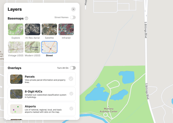
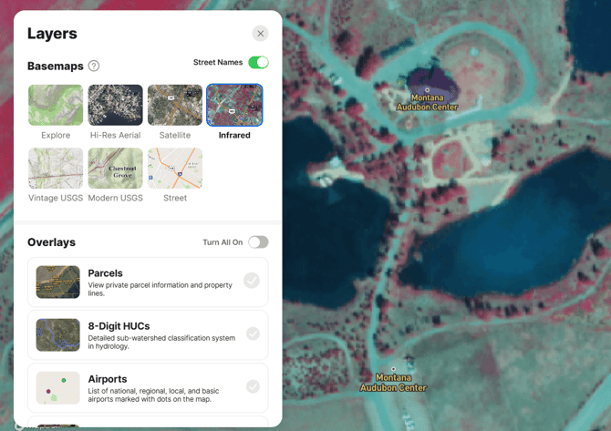
Available basemaps
Land id Basemaps include:
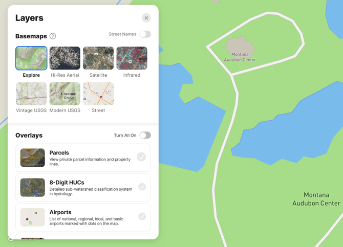
Explore Basemap
Best for exploring larger areas around a property to find natural features, built features and important places.
Our Explore Basemap is a general-purpose map highlighting outdoor and wilderness locations and urban points of interest. Whether you're looking for a resource to identify hiking, biking, running, skiing, off-road opportunities, or simply a good walking path to your favorite coffee shop, theater, or library, the Explore Basemap has you covered. This map shows you roadways, trails, businesses, topography, buildings, parks, rivers, streams, ponds, lakes, and so much more, all presented in an appealing cartographic style.
Coverage: Planet Earth
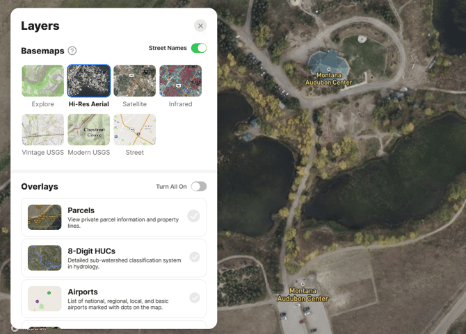
Hi-Res Aerial Basemap
Our highest resolution basemap. Best for identifying detail when mapping up close and for showcasing smaller properties.
Hi-Res Aerial imagery offers a high-resolution with accurate vertical views of your area of interest without the distortion caused by leaning buildings, trees, engineered structures and other surface features. Because each pixel is depicted in its accurate orthographic representation, as if viewed directly from above, aerial-derived true orthophotos are optimal base maps for projects that demand an unobscured view of the ground. Imagery is captured entirely by aircraft during optimal conditions, which helps minimize clouds, shadows and other effects that negatively impact or obscure the data.
Coverage: Contiguous US (excludes Hawaii and Alaska)
Note: The Hi-Res Aerial basemap is only available on Land id Premium, Pro, and Pro Unlimited Plans.
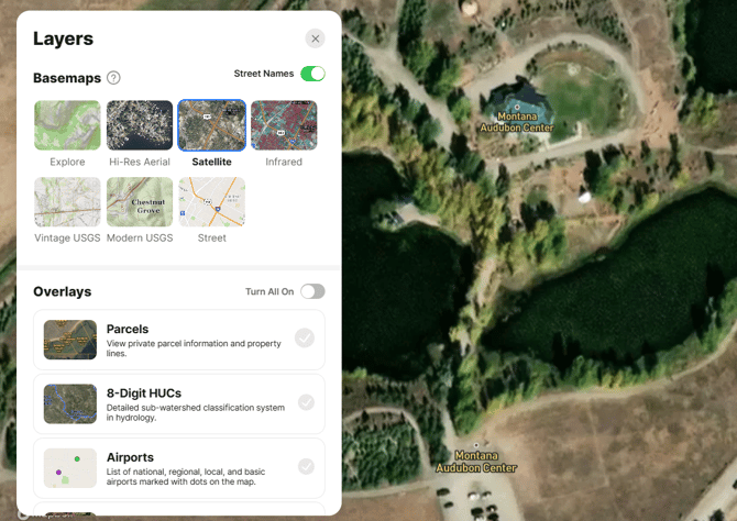
Satellite Basemap
Best for showcasing large properties or building maps at regional scales.
Mapbox combines multiple sources of global satellite imagery from commercial providers, NASA and USGS. Optimized for coverage and consistency, this basemap is continually updated with high-quality, attractive imagery as landscapes change. This imagery data comprises datasets from MODIS, Landsat 5 and 7, Maxar GBM and Vivid products, Nearmap, and NAIP imagery from the USDA.
Coverage: Planet Earth
Infrared Basemap
Best for detailed mapping in heavily vegetated areas where features like fence lines and trails are obscured; analyzing a property's forest or crop patterns; crop stress tracking; monitoring fertilizer applications; and crop yield estimation.
This imagery is part of the USDA NAIP product. Color infrared (CIR) imagery represents near-infrared light, invisible to the human eye, as red. Color infrared (CIR) is especially useful because the internal cell structure of healthy plants reflects near-infrared wavelengths. Because the healthy green vegetation appears bright red, a CIR image is also known as a “false color” image.
These images can be interpreted as follows:
- Intense bright red: Vibrant shades of red typically signify vigorously growing, dense vegetation rich in chlorophyll content.
- Lighter shades of red, magenta, and pink: These hues generally indicate vegetation with lower chlorophyll levels, such as mature evergreen forests or agricultural fields nearing the end of their growing season. Additionally, dead or unhealthy plants often appear in subdued red, green or tan shades.
- White, blue, green, or tan: These colors commonly represent soil types. Darker soil tones often signify higher moisture levels or organic content. Soil composition influences color, with clayey soils appearing as darker tans and blue-greens, while sandy soils present as white, gray, or light tan. Crops approaching the end of their growing cycle or unhealthy vegetation may display light reds, pinks, greens, or tans. Pale or light blue hues can also indicate sediment-laden water. Man-made structures such as buildings, concrete and dry gravel typically appear white to light blue in CIR imagery.
- Dark blue to black: Water bodies range from shades of blue to black, depending on their clarity and depth. Generally, more transparent water appears darker in color. However, shallow streams may exhibit colors influenced by the materials in their beds. For instance, sandy stream beds can produce a white or very light tan color due to sand's reflective properties. Asphalt roads often appear dark blue to black in CIR photos.
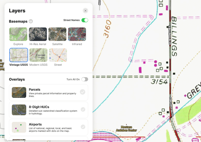
Vintage USGS Basemap
Best for mapping trails, geologic features, fire roads, wells, caves, and fences. It is also beneficial for analyzing topography and hydrologic flow.
This basemap comprises the last versions of each of the original topographic quadrangle maps that so many of us grew up with. These classic maps ended their production in 2006 but remain a popular reference in many industry and recreation applications. Aside from their utility, they can add an authentic and familiar basemap image to your maps.
Coverage: United States of America
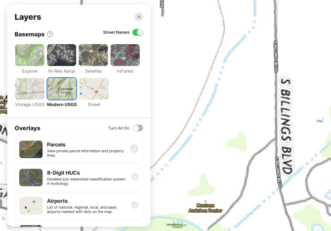
Modern USGS Basemap
Best for mapping trails, geologic features, and fire roads. It is also beneficial for analyzing topography and hydrologic flow.
The modern USGS topographic maps began production in 2009 and retain many of the characteristics of historical topographic quadrangle maps while adding updated styles. This basemap offers a cleaner and more current option for creating maps where aerial/satellite imagery might not be the best fit.
Coverage: Contiguous United States (excludes Hawaii and Alaska)
Street Basemap
Best for general reference mapping, topographic representation (hillshade), and regional location maps.
Our Street Basemap is a classic OpenStreetMap-derived reference map with geometries for roadways, terrain, administrative boundaries, building footprints, land use classifications, rail stations, points of interest, and more. It is helpful at any scale as a situational reference tool and has an easily understood format.
Coverage: Planet Earth