---
title: Abstracts Overlay
description: Learn about the Abstracts Overlay, including the definition, benefits, tips, coverage and update frequency.
---
[Skip to content](https://support.id.land/abstracts-overlay#main-content)
[](https://id.land/)
Open main navigation
Close main navigation
- [Contact Us](https://id.land/contact)
[Contact Us](https://id.land/contact)
How can we help you?
- There are no suggestions because the search field is empty.
1. [Land id Help Center](https://support.id.land/?hsLang=en)
2. [Product Tutorials](https://support.id.land/product-tutorials?hsLang=en)
3. [Property Information](https://support.id.land/product-tutorials?hsLang=en#property-information)
# Abstracts Overlay
## Learn about the Abstracts Overlay, including the definition, benefits, tips, coverage and update frequency.
Available with any of the following [subscriptions](https://id.land/pricing):
- All plans
#### Definition
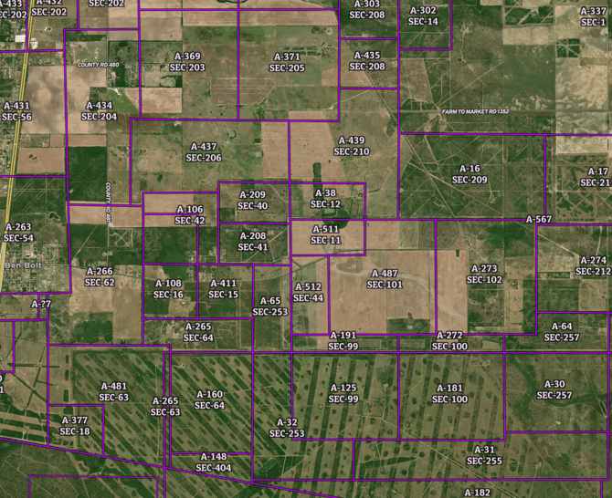
The Abstracts Overlay describes survey abstract boundaries. These land units are the basic building blocks of the Original Texas Land Survey. Each one of them typically has a unique abstract number within each of the 254 Texas counties. These have been used for decades to describe where new, subdivided portions of these Spanish- and Mexican-era land grants relate to the original delineations. The Abstract Overlay is analogous to the PLSS Overlay available in other states.
#### Key Benefits
- A useful tool for locating land based on a legal description
- The Abstract Overlay is fully searchable by county and abstract number in the Land id search bar.
**Tip:** Each label includes the abstract and section number.
**Limitation:** This layer should be used for reference only. These boundaries have been transcribed from old paper maps; spatial and attribute errors are possible.
#### Coverage
Texas
#### Update Frequency
As updates are available
- [Get Started](https://support.id.land/get-started?hsLang=en)
- [Product Tutorials](https://support.id.land/product-tutorials?hsLang=en#main-content)
- [Property Information](https://support.id.land/product-tutorials?hsLang=en#property-information)
- [Map Creation](https://support.id.land/product-tutorials?hsLang=en#map-creation)
- [Using and Sharing Maps](https://support.id.land/product-tutorials?hsLang=en#using-and-sharing-maps)
- [Marketing Properties Training](https://support.id.land/marketing-properties-training?hsLang=en)
- [Organization Plan](https://support.id.land/organization-plan?hsLang=en)
- [Billing and Subscription](https://support.id.land/billing-and-subscription?hsLang=en)
- [Troubleshooting](https://support.id.land/troubleshooting?hsLang=en)
- [Partnership](https://support.id.land/partnership?hsLang=en)
- [Legal](https://support.id.land/legal?hsLang=en)
Copyright © 2025, Land id®